Table of Contents: - An Introduction to Geological Time Frames- Ralph Haugerud - What is Puget Sound? (and the Puget Lowland, and the Puget Sound Basin?)- Ralph Haugerud - Physiographic Provinces- Ralph Haugerud - Geology--Deposits Record History- Ralph Haugerud - Geomorphic Elements of the Puget Lowland- Ralph Haugerud - Evolution of Drainage Network- Ralph Haugerud
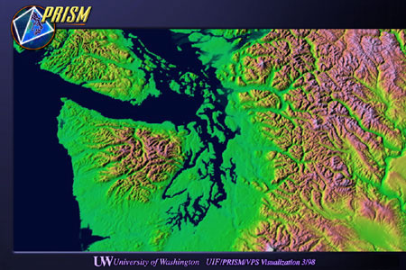
AN INTRODUCTION TO GEOLOGICAL TIMEFRAMES: GEOLOGISTS UNDERSTAND TIME DIFFERENTLY 1) A million years ago is like yesterday. Modern means "happening now", and in the context of Puget Sound, this means the last 13,000 years. On a different time scale, geologic processes in the Pacific Northwest have been mostly the same for the last 40 million years or so. Most events of a year, or a century, are unlikely to have much effect on the landscape several millenia--let alone million of years--later. We humans may be a passing aberration. 2) Geologists measure time with several yardsticks and sometimes have a hard time converting from one yardstick to another. You and I measure time with a wristwatch and a calendar (calendar years). Some geologic deposits are dated by the abundance of rapidly decaying radioactive carbon atoms (radiocarbon years)(see note below). Other deposits and rocks are dated by way of the fossils they contain (relative time, e.g. Pleistocene, Oligocene) and conversion of these ages to years of any kind is approximate--it is like assigning a numerical age to the Neolithic. Many geologic features and events are dated with the tools of physical stratigraphy--correlating bedding, or the compositional patterns in rocks believed to be stratified, from the place where phenomena are observed to another locale where the rocks can be dated. As you might expect, this process involves a great deal of inference. 3) Lots of time geologists can't measure at all. If there are no deposits, we don't know what happened or when. Much of geology is about reasoning around the huge gaps in the depositional record. 4) Geologists use strange abbreviations. Ma means millions of annums. ka is thousands of annums. And we use Ma and ka to refer to both dates (a certain instance in time, located by how long before present it was) and durations. WHAT IS PUGET SOUND? (AND THE PUGET LOWLAND, AND THE PUGET SOUND BASIN?) Puget Sound Edmond Meany (1923) described Puget Sound as "a name much extended beyond its original application." In 1792 Captain George Vancouver named the bays and inlets south of present Tacoma and The Narrows after Lieutenant Peter Puget. In 1837, US Navy personnel referred to "the 'Straights of Juan de Fuca' and 'Pugitt's Sound', thus extending the name so as to include Admiralty Inlet." In 1857, James Swan complained that ignorant San Francisco newspaper reporters were using Puget Sound to refer to all the waters on the north of Washington Territory. In 1859, a US Army general placed Vancouver Island "in Puget's Sound". The 1866, the Washington Territorial Legislature placed the San Juan Islands in Puget Sound. In 1913, the Superior Court of Clallam County decided that, for the purposes of fishing laws, the Strait of Juan de Fuca was part of Puget Sound. The Native American name for Puget Sound [which Sound?] is Whulge. Puget Lowland is a physiographic region--with distinctive landforms, geology, land cover--that is centered on Puget Sound. Puget Sound Basin is the area that drains into Puget Sound. The Puget Sound Basin is more extensive than the Puget Lowland, as it includes extensive portions of the Cascade Range and the Olympic Mountains. Some Comments Despite KPLU, real Washingtonians never speak of the Puget Sound. The PRISM definition of Puget Sound matches current common usage: salt water south of a line drawn from Port Townsend to Anacortes. This includes Admiralty Inlet, the Skagit River and its tributaries. This Puget Sound corresponds to a Puget Lowland that is bounded on the north by the San Juan high. The Strait of Juan de Fuca, Bellingham Bay, Georgia Strait, ... are not part of Puget Sound. However, the glacial geology, geomorphology, land cover, land-use pattern, tidal circulation pattern and fisheries that typify Puget Sound and environs extend north into the Georgia Depression. Perhaps the Salish Lowland would be a more useful analytical focus. Unfortunately, the corresponding drainage basin includes much of British Columbia (short streams tributary to Georgia Strait as well as the Fraser basin) and two regulatory environments. Region surrounding Puget Sound = Puget Lowland Puget Lowland is part of larger Salish Lowland-
Pliocene (2 - 5 Ma) Miocene (5 Ma - 23 Ma) Oligocene/ latest Eocene (24 - 40? Ma) Note that:
Cascade arc Cascade arc volcanoes began erupting about 35 Ma ago, a result of a change in plate motions in the NE Pacific region that occurred at 42 Ma. The regional tectonic regime has been roughly similar ever since. Cascade and Olympic Mountains There is indirect evidence for uplift in the vicinity of the Olympic and Cascade mountains as early as 15 Ma, but we do not know that the mountains were as high then as they are now. The mountain ranges to the east and west of the Salish Lowland may be mostly younger than 15 Ma. Glaciation The first glaciers in the Salish Lowland, some 2 Ma ago, probably flowed across a preexisting topographic low. Deposits in the lowland record at least 6 glacial episodes, each lasting (by analogy with better-studied deposits elsewhere) thousands to tens of thousands of years. We know little about the details of the first 5 glaciations, but presume that the much more accessible deposits of the last glaciation record a process that occurred many times before. The last (Fraser) glaciation began about 25 ka and lasted until about 10 ka. The early phase of the Fraser glaciation, known as the Evans Creek stade from deposits SE of Seattle (near Vancouver, BC it is called Coquitlam) was protracted alpine glaciation, with ice growing in the Cascades and Coast Mountains and forming valley glaciers in the mountains. Evans Creek ice may have locally reached the margin of the Puget Lowland. After about 18 ka, ice began advancing south across the Salish Lowland from sources in the Coast Mountains, the interior of British Columbia, and the North Cascades. This ice advance is known as the Vashon stade. When Vashon ice reached the latitude of Seattle (after 15 ka), Evans Creek ice had retreated, and Vashon ice blocked the west-draining valleys of the Cascade Range.
When Vashon ice reached the NE corner of the Olympics, it blocked the Puget Lowland and turned the lowland into a large lake. Glacial outwash filled the lake with clay and silt, then sand as the ice grew closer. As the lake filled it was converted into a floodplain, floored with coarse alluvial deposits carried by rivers flowing off the ice. The lake in front of the Vashon lobe, and the rivers that replaced it, drained south via Black Lake near Olympia into the Chehalis river and thence to the sea. The modern lower Chehalis River is now underfit--the present stream is too small to have carved its valley. (Clague, 1994 adapted from Blaise et al, 1990. fig.11)
The proglacial lacustrine and alluvial deposits were then overridden by the ice sheet, the whole depositional stack sculpted by flowing ice and running water at the base of the glacier, and the deposits immediately beneath the glacier churned into a few meters thickness of glacial till. As the ice wasted away, rivers flowing across the bare landscape quarried and redeposited large amounts of debris. (Booth and Goldstein, 1994)
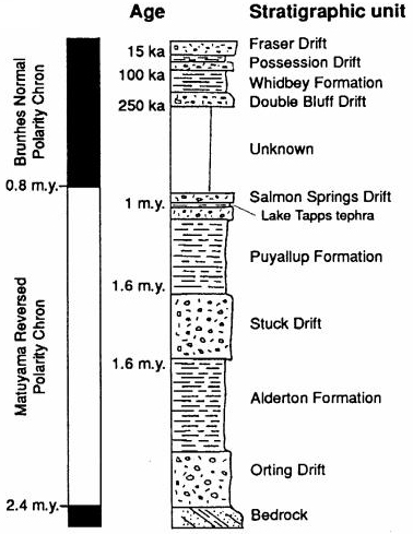
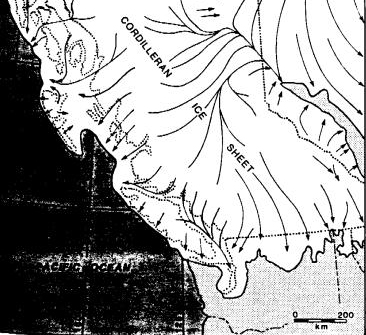
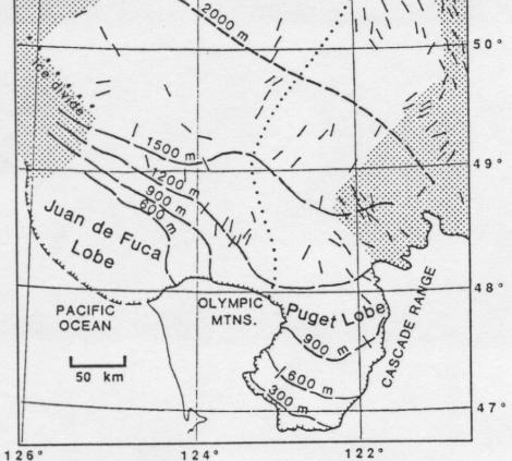
Vashon ice was short-lived! Seattle was ice-free at 15 ka, ice-covered afterwards, and ice-free again by 13.5 ka. Ice retreat was especially rapid, probably because as the ice thinned it reached a critical thickness in the Strait of Juan de Fuca and floated, retreated eastward by calving, and the ice sheet remaining in the Puget Lowland was beheaded. Ice lingered longer in the Fraser lowland; the youngest glacial deposits there date to about 10 ka. The following two illustrations depict the timing of the Cordilleran Ice Sheet and the Puget and Juan de Fuca lobes. Time-distance diagram for Fraser glaciation.(Clague, 1991) Time-distance relations for Vashon stade of Fraser glaciation. (Booth and Goldstein, 1994) The result was the following stack of deposits
The most abundant material by surface area in the Puget Lowland is till of Vashon age. (South and east of Tacoma there is extensive recessional outwash.) However, the till is commonly a thin veneer, and the majority by volume of the Vashon-age glacial material in the lowland is advance outwash. Our landscape can be decomposed into the following elements, going
from the most fundamental to the least--imagine a crude Fourier
analysis of the topography:
* ybp =radiocarbon years before present. Not calendar years; exact correlation is uncertain. 15,000 radiocarbon years before present is about 18,000 calendar years ago. The variation is primarily because of temporally varying, and uncertain, rate of production of radioactive carbon by cosmic-ray bombardment. Landforms 1, 2, 3, 4 were all formed during last (Vashon) glaciation, between about 15,000 and 13,500 ybp. There are few--beyond the lowland hole--pre-Vashon relicts. Landforms that reflect processes acting now are 2.1, flat floors of big troughs and 5, small gullies that dissect edges of region and local beach bars and spits, landslides, etc. Glaciation greatly rearranged the drainage network in the Pacific Northwest. The evidence for the process is clearest in the eastern North Cascades, north of Winthrop, where there is an east-west drainage divide just south of the border. Vashon-age ice advancing south from British Columbia dammed north-flowing streams tributary to the Similkameen River. The resulting lakes spilled over high passes to the south. Fluvial erosion lowered the passes and moved the drainage divides to the north. Primary evidence is extensive fluvial scour and coarse fluvial debris in south-draining valleys tributary to the Methow River, and lake deposits in north-draining valleys immediately to the north. The process must have been repeated during each glacial cycle, perhaps at least 6 times during the course of the Pleistocene. The most conspicuous drainage rearrangement in the eastern North Cascades is the erosion of a former divide north of Mazama, incision of the Lost River Gorge, and addition of about a township (circa 100 km2) of formerly north-draining area to the Methow drainage. The Lost River Gorge is a spectacular trail- and road-less box canyon nearly 1500 m deep. On the 1:100,000 scale map, 250-m index contours disappear under overhangs on the canyon walls. Less clear, but still convincing, landform evidence indicates that prior to Pleistocene glaciation (before 2 Ma) the west-flowing Skagit River was a short stream similar to the modern Baker River or Cascade River, starting at a north-south divide near the site of the present Gorge Dam just upstream of Newhalem. The upper Skagit River drained north into British Columbia until a proglacial lake--dammed by south-advancing ice--spilled over a pass along the then-Cascade Crest in the Gorge Dam area and incised the Skagit Gorge. But the biggest Pleistocene rearrangement of them all is the Fraser River. On the east side of the Coast-Cascade mountains, northeast of Hope, BC, several-million-year old main-channel gravel deposits record the existence of a former north-flowing Fraser River. West of the Olympic Peninsula, the Nitinat deep-sea submarine fan--whose sediment comes from the Strait of Juan de Fuca--appears not to have existed prior to about 2 million years ago. The obvious conclusion is that prior to the Pleistocene (circa 2 Ma), most of the interior of southern British Columbia--the present upper Fraser drainage--was tributary to the Peace River, which flows through the northern Rocky Mountains and thence east and north to the Arctic Ocean via the Mackenzie River. The present continental divide--at Summit Lake, north of Prince George, B.C.--is a swamp that Alexander Mackenzie and his companions paddled (and portaged) across in 1754, during the first European traverse of North America north of Mexico. Prior to the Pleistocene, the continental divide must have been near Hope, B.C., at the crest of the Coast Mountain-Cascade Range crest. There have been more recent, though minor, changes in the drainage network around Puget Sound. Prior to digging of the Montlake Cut, in the early 1900s, Lake Washington and all the streams tributary to it drained into the Duwamish River via the Black River at Renton. In the late 1800s, the White River (southeast of Auburn) at times flowed south into the Puyallup, and at other times flowed north into the Duwamish, changing course as various logjams were rearranged by floods or dynamite. Its present course (into the Puyallup) reflects the will of King County farmers who had more dynamite than their brethren in Pierce County. Farther north, at the Skagit-Whatcom County line, the South Fork of the Nooksack appears to have recently (to a geologist) flowed south into the Samish River--though there is no historical record of this. Substrate Much of the Puget Sound basin is dominated by till and advance outwash. There is relatively little near-surface bedrock. One might suspect that groundwater flow is more important than in basins in SW Washington and on the east slope of the Cascades. Geomorphology Unlike most landscapes, ours is not primarily river-carved. Low-elevation, moderate-relief areas are more extensive than in comparable salmon-bearing drainages outside the Salish Lowland (Coastal Oregon and SW Washington, east slope Cascades, northern BC coast and SE Alaska). Change The Puget Sound basin didn't always look like it does now. There were no salmon in Puget Sound 14,000 (radiocarbon) years ago! Two million years ago, the upper Skagit River didn't drain to Puget Sound and most of the present Fraser drainage was tributary to the Arctic Ocean or Hudsons Bay. Booth. D.B. and Goldstein, B., 1994, Patterns and Processes of Landscape development by the Puget lobe ice sheet: Washington Division of Geology and Earth Resources, Bulletin 80, p. 207-218 Thorson, R.M. 1989, Glacio-isostatic response of the Puget Sound area, Washington: Geological Society of America Bulletin, v. 101. n.9, p. 1163-1174. Illustrations, or quotes were borrowed from the following works: Clague, John J., 1991, Quaternary glaciation and sedimentation, Chapter12 in Geology of the Canadian Cordillera, H. Gabrilse and C.J. Yorath, editors: Geological Survey ofCanada, Geology of Canada, no. 4, p.419-434. Clague, John L., 1994, Quaternary stratigraphy and history of south-coastal British Columbia, in Geology and geological hazards of the Vancouver region, southwestern British Columbia, J.W.H. Monger, editor: Geological Survey of Canada, Bulletin 481, p. 181-192. Easterbrook, Don J., 1994, Chronology of Pre-Late Wisconsin Pleistocene sediments in the Puget Lowland, Washington: Washington Division of Geology and Earth Resources, Bulletin 80, p. 191-206. McKee, Bates, 1972, Cascadia: The geologic evolution of the Pacific Northwest, New York, McGraw Hill,394 p. Meany, Edmond S., 1923, Origin ofWashington Geographic Names,Seattle, University of Washington Press.
|