 |
|
Table of Contents:
- Physical Oceanography in Puget Sound- Julie Nelson
- Biological Oceanography in Puget Sound- Julie Nelson
- Salmon and Oceanography- Bob Francis
Adapted from:
Robert Burns' The Shape and Form of the Puget Sound , Seattle: Washington Sea Grant, University of Washington Press, 1985.
John Downing's The Coast of the Puget Sound, Its Processes and Development, Seattle: Washington Sea Grant, University of Washington Press, 1983.
Richard Strickland's The Fertile Fjord, Plankton in the Puget Sound. Seattle: Washington Sea Grant, University of Washington Press, 1983.
The physical oceanography of Puget Sound is highly variable, both temporally and spatially. In general, the Sound covers an area that ranges from 2,632 square kilometers to 2,329 square kilometers from low to high tides. Tidal fluctuation in the volume of the Puget Sound Basin that is flooded changes on daily, seasonal annual and interannual scales. Similarly, seasonal influxes of freshwater change dramatically from low volumes in late summer to a major peak in December/ January and a secondary peak in June/ July as spring thaws winter snows in the high country. These low-density fresh or brackish waters atop lower layers of salt water are relatively resistant to vertical mixing. The boundary between salt and freshwater layers (the halocline) is a physical barrier to mixing. The stronger the density difference between layers (pycnocline), the stronger the stratification between layers. Thus the Puget Sound also illustrates seasonally related variation in stratification. Mixing of water types and stratification of water types is patchy in time and space throughout the Sound.
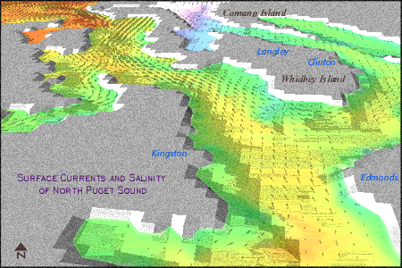
For example, a view of the somewhat patchy variation in salinity in relation ot surface currents in North Puget Sound is illustrated by the following image.
In the above illustration reds and oranges indicate relatively high levels of salinity, whereas blues and greens display less saline areas. Yellow illustrates areas of moderate salinity.
The following section discusses physical delineations in Puget Sound, and tidal and seasonal circulation patterns. The variation in the physical configuration of water in the Puget Sound is reflected by its chemical configuration (salinity) as well as biological productivity, which will be discussed in the next section titled "Biological Oceanography in Puget Sound."
Topography/ Bathymmetry
There are four major divisions in the Sounds which are bathymmetrically determined by the presence of sills, or submarine ridges that constrict the flow of water from one subdivision of the Puget Sound Basin to the next: The Main Basin, Whidbey Basin, Southern Basin, and Hood Canal Basin. The Main Basin is comprised by Admiralty Inlet and the Central Basin.
The relative volume, area, shoreline and tideland in each basin is illustrated in the following tables adapted from (Burns, 1990, p. 59).
Each subdivisions' percentage of the 2,329 sq. km comprising Puget Sound is illustrated below
|
(MainBasin) Admiralty Inlet 16% |
(MainBasin) Central Basin 30% |
Whidbey Basin 23% |
Southern Basin 16% |
Hood Canal 15% |
The 168 cubic kilometers of water inundating the Puget Lowland to form Puget Sound, can be divided into the relative percentages of volume depicted in the following table:
|
(MainBasin) Admiralty Inlet 13% |
(MainBasin) Central Basin 46% |
Whidbey Basin 17% |
Southern Basin 9% |
Hood Canal 16% |
Of the 2,141 km of shoreline surrounding the Sound, each basin possesses the following percentage:
|
(MainBasin) Admiralty Inlet 8% |
(MainBasin) Central Basin 25% |
Whidbey Basin 22% |
Southern Basin 29% |
Hood Canal 16% |
Of the 303 sq. km of tideland abutting the waters of the Sound, each basin possesses the following percentage:
|
(MainBasin) Admiralty Inlet 6% |
(MainBasin) Central Basin 16% |
Whidbey Basin 43% |
Southern Basin 21% |
Hood Canal 14% |
The largest subdivision, by volume, is the Main Basin. It holds 60% of the water in the whole system. Pictured above, it extends 100 kilometers from Admiralty Inlet to Commencement Bay in Tacoma. it ranges in depth from 65 m at Admiralty Inlet to over 280 m deep in the Main Basin, just south of Kingston.
Whidbey Basin, the second largest of the four subdivisions comprising Puget Sound contains the waters east of Whidbey island and North of the Main Basin. There is no sill across the entrance to the Whidbey Basin, therefore, it is more a geographically than geologically defined region. It is a much shallower basin, in comparison to the Main Basin, and ranges in depth from 8 m in Skagit Bay to 177 m in Saratoga Passage, between Whidbey Island and Camano Island. This relative shallowness is accompanied by a much higher percentage of tidelands than any of the other basins.
The Southern Basin, is partially separated or demarcated from the Main Basin by a prominent sill, The Narrows. The deepest connection over the sill is only 45m which quickly drops to the maximum depth of the Southern Basin, 188 m, on its southern side. The mean depth in the Southern Basin is only 37 m. Similar to the Whidbey Basin, the relatively shallow depth in the Southern basin yields large areas of tidelands. These tidal areas are also a result of tremendously varied topography. The shoreline in the Southern Basin is incredibly complex due to the number of islands and inlets animating its topography.
The Hood Canal Basin is the simplest and smallest of Puget Sound's subdivisions. The entrance to Hood Canal lies between Tala Point and Foulweather Bluff, however the entrance sill to this basin lies considerably south. It is 50 m in depth and located between South Point and Lofall. The deepest water in this basin, over 188 m, lies in Dabob Bay, between the Olympic and Toanados Peninsulas.
Tidal Circulation
The pattern of net circulation , averaged over several tidal cycles, resembles that of an estuary. River water flows seaward on the surface, pulling with it several times its volume of salt water. To replace this volume of water moving seaward on the surface, saltwater flows into the basin at depth. This circulation pattern however, is complicated by two daily tidal fluctuations. The seaward flow of surface water strengthens substantially during the ebb tide, and slows during the flood tide. Similarly, the inward flow of saltwater at depth increases during the flood tide, but slowed during ebb tides. This creates a pattern of horizontal and vertical mixing in the waters of the Puget Sound. The following illustrations effectively depict the fluctuation in currents effecting the Sound, induced by tides. This first image (Strickland, 1983, p. 42) illustrates the landward currents produced by flood tides. Mixing over sills is evident, most notably at Admiralty Inlet and The Narrows.

This second image, (Strickland, 1983, p. 43) depicts the currents resulting from an ebb tide. As is depicted, there is weak landward flow. As a result surface water flows seaward, dragging with it lower layers of salt water ( entrainment). Two thirds of the surface flow is mixed into the Main Basin through entrainment and mixing over sills. Low salinity areas are present near major river mouths.

Seasonal Circulation
Accompanying a seasonal change in precipitation (peaking in winter), are changes in wind and weather patterns. Though the Puget Sound is protected from many of the severe Winter storms affecting the Pacific Coast, the effects of wind upon surface waters can be substantial. Wind can generate substantial waves on the surface of Puget Sound, as well as generates currents in the direction that it blows. Winds are most influential when their direction coincides with the long axis of a body of water, for example, are blowing north- south along the entire length of the Main Basin. The following illustrations (Downing, 1983, p. 63) depict the seasonal patterns of winds over western Washington.

Storms which bring high winds to the Puget Sound accompany both high and low pressure systems. Low pressure systems, bring cool rainy weather. Extratropical cyclones develop in deep low pressure systems in the central North Pacific. Occasionally these storms cause sea level to rise due to a localized depression of atmospheric pressure, and with their strong, short lived wind bursts, they generate substantial wave activity and initiate a landward flow of surface waters. The frequency of extratropical cyclones is greatest in winter. Severe storms can also occur when cold high pressure masses move over the cascade Mountains from the east, and settle in the Puget Sound Lowlands. The predominant wind directions from these storms is northerly and their duration, several days, can be far longer than cyclonic storms.
Adapted from Richard Strickland's The Fertile Fjord; Plankton in Puget Sound Washington Sea Grant, University of Washington, 1983
The biological configuration of the Puget Sound is inextricably tied to its physical and chemical configuration. Like both of these aspects of Puget Sound oceanography, the biological characteristics are highly variable in time and space. This section introduces organisms and concepts and processes defining the biological production of Puget Sound.
Plankton
Plankton are diminutive organisms, passively drifting or weakly swimming throughout Puget Sound. Though seemingly insignificant, these organisms are the foundation for a complex and very productive food web in Puget Sound. This section introduces you the cast of tiny characters that is the basic building block for all biological productivity in Puget Sound.
There are two major divisions of plankton: phytoplankton and zooplankton. Phytoplankton are primary producers, microscopic plants, which photosynthesize to produce their own food, which in turn provides nutrients for other organisms, or secondary consumers. Zooplankton are microscopic animal forms which graze upon phytoplankton and each other as they develop. Zooplankton provide food for other large aquatic organisms, like fish, mollusks and mammals, that subsequently feed birds, and other aquatic and terrestrial mammals.
In addition to generating food for an entire web of organisms, plankton provide other essential nutrients, notably oxygen. Strickland (1983, p. 3)
Phytoplankton today produces 95% of the oxygen generated in the sea, and at least one third of the earth's oxygen... While most marine oxygen come form the expanses of the open oceans, areas such as the Puget Sound are more than ten times as productive for their area.
However, the decay of phytoplankton strips oxygen from water. Oxygen depletion is highly probable after a plankton bloom in portions of the Sound receiving relatively little circulatory activity.
Phytoplankton can only photosynthesize in the proper range of light intensity, temperature, nutrient and salinity conditions. The nutrients required by phytoplankton growth are nitrogen, phosphorous, carbon, potassium, sodium, calcium, and sulfur, all of which are common in some form in the sea. Also important are trace metals like, iron, manganese, cobalt, copper, nickel, tin and zinc. Nutrients are present in salt water in fairly constant ratios, which does not necessarily match the growth demands of phytoplankton given optimum growing conditions. In salt water, nitrogen is believed to be the limiting nutrient to plant growth. There are areas in which nutrient limitation is well documented, although these areas are in the minority. Examples are sheltered embayments, such as those in the South Sound in late summer. In most of Puget Sound, light availability seems to be the primary limiting factor for plankton production.
Phytoplankton
All phytoplankton cells have an outer cell membrane and inner cytoplasm. Some have an armored cell wall that is believed to have a variety of functions, such as inhibiting grazing by zooplankton. All reproduce asexually, by cell division, during which a parent cell divides itself into two offspring cells. Needless to say this sort of reproduction introduces an exponential growth curve while conditions are favorable. Phytoplankters can sexually reproduce as well in certain environmental conditions. In this process, a parent cell dissolves into sperms or eggs, which combine in the water column to produce zygotes.
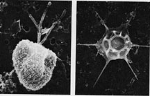
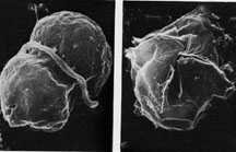
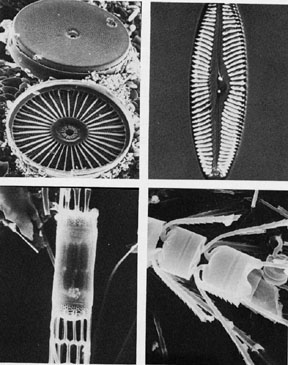
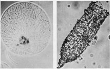
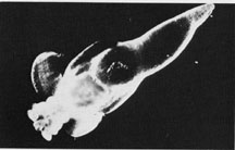
The three primary categories of plankton in Puget Sound are determined by the physical characteristics related to their locomotion. Several very small unicellular organisms propel themselves with whip-like flagella. The photosynthetic varieties of these "flagellates" are termed phytoflagellates. Dinoflagellates include plant and animal forms that have two flagella and a unique cell structure. Diatoms have no flagella and relatively little locomotion. Examples of each category are pictured below (Strickland, 1983, p. 19).
These first images depict two varieties of phytoflagellates. On the left is a green flagellate, approximately 8 micrometers in actual size (most likely Pyramimonas). Note the flagella. To the right is the skeleton of Dichtyocha a golden-brown silicoflagellate, 50 micrometers in size. (Photos by Susan B. Stanton) This category is difficult to study because of its small size, and is proving to be much more abundant than previously believed.
The two images below depict two types of Dinoflagellates, to the left Gymnodinium and to the right, Gonyaulax. Gymnodinium is approximately 6 micrometers in size, and clearly illustrates a single flagellum running through the transverse groove. Gonyaulux, 30 micrometers in size, illustrates an armored shell, and is the cause of paralytic shellfish poisoning.( Photos by Beatrice C. Booth)
Pictured below are four varieties of diatom. The top left micrograph (National Marine Fisheries Service, NOAA, by Michael Eng) illustrates Coscinodiscus. The top right image depicts Navicula (School of Oceanography, UW). The bottom left image illustrates a chain of diatom Skeletonema (B. Dumbald). The bottom right photo depicts a Chaetoceros (Beatrice C. Booth).
Zooplankton
Like, phytoplankton, zooplankton can be divided into several categories. Zooplankton comprise many diverse groups of animals. Several phyla in marine environment have a planktonic phase as one or more developmental stages. Zooplankton are far more mobile than phytoplankton, and have far more sophisticated survival, foraging, and protection strategies. Sexual reproduction is the dominant form of reproduction for the zooplankton.
One category of zooplankton are the protozoans. These unicelluar organisms reproduce like phytoplankters, primarily by cell division or binary fission. They feed on very small phytoplankton and bacteria. Two illustrations (Strickland, 1983, p. 24) of protozoa are pictured below (Alexander J. Chester). The picture on the left shows Noctiluca, a dinoflagellate protozoan 100 micrometers in actual size. On the right is Tintinnopsis, a protozoan approximately 100 micrometers in length.
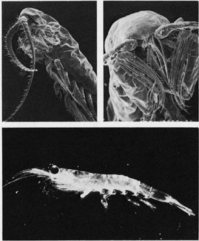
Another category of zooplankton are the crustaceans. By far the most common order of crustaceans are copepods. Copepods eat plant and animal food and their sizes and feeding structures are specifically adapted to their primary food source. Other members of larger shrimp-like planktonic crustaceans are the euphausiids, mysids, and hyperiid amphipods. These orders live in deeper waters than most copepods feeding on large phytoplankton, protozoa, copepods, fish larvae etc. Many of these organisms undertake a daily migration to deeper waters (100m) during daylight hours. Crustaceans rely upon sexual reproduction. Examples of an herbivorous copepod (upper left), carnivorous copepod (top right) and euphausiid " krill" (bottom) are pictured below ( Strickland, 1983, p. 24,Courtesy Mark D. Ohman).
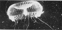
Coelenterates or Cnidaria, which includes anemones and corals, are planktonically represented by species of floating or swimming jellyfish in the Sound. Two phases animate the animals' lifecycle, the medusa and the hydra. Hydras are asexual and bud off of medusae. Medusae carry out sexual reproduction as the drift. Cnidarians feed by poisoning prey with cnidoblasts, special cells that eject a thin cord tipped with a poison dart. An illustration of Aequoria follows (Strickland, 1983, p. 25, Courtesy WIlliam D. Waddington)
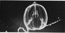
Ctenophores are another category of zooplankton formerly considered to be Coelenterates. Ctenophores are also known as "comb jellies" for the eight rows of paddle like cilia that visually divide their bodies into sections, like an orange. These fused cilia are ctenophores means of propulsion. Pleurobrachia , pictured below, has long tentacles to catch but not poison its prey, which consists primarily of zooplankton (Strickland, 1983, p. 25 CourtesySchool of Oceanography, UW).
Mollusks are another category of zooplankton. "Sea butterflies" or the pteropods, include Limacina and Clione. Limacina has little swimming power and is a passive filter feeder. Clione is a large carnivore that swims by beating flaps of skin, resembling the "foot" of terrestrial snails, on its underside. Pictured below is Clione, approximately 3 centimeters in length (Strickland, 1983, p. 25, Courtesy School of Oceanography, UW)
In addition to these major zooplankton categories, several other species have meroplanktonic larvae. This includes the eggs and larvae of organisms inhabiting the water column ( fish) intertidal zone (barnacles, sea cucumbers, mussels, etc.) and bottom sediments (annelids). These eggs and larvae float to the surface to access warmer water and increased food supply, then settle to the bottom in response to subtle chemical and biological cues.
Plankton and Physical Processes in the Puget Sound
As discussed before, phytoplankton needs adequate light and nutrients to grow. However, in Puget Sound, the aquatic medium in which plankton live is constantly changing; enhancing and inhibiting access to light and nutrients.
As discussed earlier, currents from storms, freshwater inputs, and tides as well as bathymmetric features like sills, strengthen of weaken the mixing process by encouraging stratification or vertical mixing. Strong vertical mixing can have a negative influence on primary productivity, by constantly mixing surface layers of water, which are exposed to more sunlight, deeper into the water column. This slows if not halts the rate of photosynthesis. However, this same process can ultimately prove beneficial for primary production., in that it brings nutrients up from deeper water layers to the surface where they are less plentiful. For photosynthesis to occur, a balance between mixing and stratification is necessary.
One condition, stratification, occurs seasonally through the winter and spring (when precipitation and snowmelt peaks, leading to an influx of freshwater to the surface layers of the Sound) and summer (when solar heating of the surface is maximal). Solar input is lowest in the winter and highest in the summer. As a result, phytoplankton growth surges in the spring, when stratification is maintained by relatively calm weather, high freshwater run-off, and the amount of sunlight increases.
In the Main Basin, the tides, twice a day, instill a very interesting striped pattern of stratified freshwater run-off alternating with mixed, nutrient rich waters flowing north from the Narrows as basin waters flow seaward. These alternating water types in the Sound provide a variable environment for plankton, so far as the chemical and nutrient configuration of water in the Main Basin is concerned.
Patchiness in time occurs due to the fact that, despite tidal oscillations, surface waters gradually traverse the length of the Main Basin in roughly six days. This movement is faster during times of heavy run-off and slower during periods of northerly winds. Upon reaching Admiralty Inlet, mixing occurs. The deep waters moving into the basin to replace the volume of water removed by entrainment are comprised largely of these mixed waters rather than water from the Strait of Juan de Fuca. A Strickland (1983, p. 48) states, "About two-thirds of the deep water entering the main basin, in fact, is thought to be Main Basin surface water caught in the deep inflow during mixing at Admiralty Inlet." This complicates the process of two-layer estuarine circulation substantially, by recirculating large volumes of water throughout the Sound. The retention of this water in the Basin has several biological consequences. The flushing rate of the Sound substantially affects phytoplankton populations by recycling and recirculating the "standing stock" during periods of heavy mixing, or flushing it rapidly seaward during periods of heavy freshwater run-off. The salinity and nutrient levels of inflowing water at depth are less than they would be if the waters were from the Strait. This reduces stratification, available nutrients and thus primary productivity.
Zooplankton distribution throughout the Sound seems to be determined by their physical dimensions as well as those of the environment. The dominant factor in vertical distribution is vertical migration. Some zooplankters reside at the surface namely, microzooplankton and larvae, however the rest of zooplankters reside substantially deeper in the water column. Zooplankton remain deeper during the day than at night and similarly, deeper during the winter than summer.
The food chain in Puget Sound, like any other trophic configuration, consists of the movement of energy from one trophic level to another, usually from lower (primary producers) to higher (secondary, tertiary consumers, decomposers). For organisms to survive, they must coincide in time and space with their prey, but this is always accompanied by a net loss of energy, resulting from the ingestion of a lower trophic level by a higher one. This cycle shows a pattern of alternating peaks between producers and consumers. A peak in primary production is followed by peaks in consumer populations followed by declines in primary producer populations which in turn leads to declines in consumer populations due to migration, sparked by declining food availability, or consumption by other links in the food web.
One very complex component of the food web are Pacific Salmon. They are discussed explicitly below.
Climate and the Puget Sound Marine Environment: A Coho Salmon Perspective
W. Pinnix and R.C. Francis
Much of this section is taken from Bill Pinnix's University of Washington, School of Fisheries MS Thesis (Pinnix 1999).
Recent studies have implicated oceanographic conditions as an important regulator of marine survival of salmon. Patterns of marine survival of coho salmon differ at both local and coastwide scales, and these differences are thought to arise from localized oceanographic conditions at the time of entry into the marine environment. The following slide illustrates the survival of coho from 1971-1992
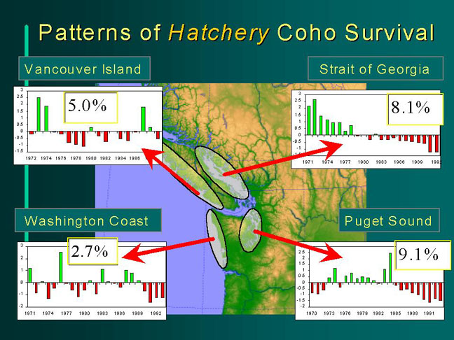
Historically, coho salmon from the Strait of Georgia and Puget Sound have had much higher marine survival than their coastal counterparts. These protected waters must provide oceanographic conditions that favor higher coho marine survival.
Climate and the Puget Sound Basin
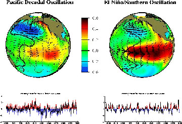
Climate of the Puget Sound region is a synthesis of large scale processes that occur at different time and space scales. Two major influences are El Nino Southern Oscillation (ENSO), an internally driven interannual cycle within the coupled ocean-atmosphere system of the tropical Pacific (Enfield 1989) and the strongest natural interannual climate process on the planet (Philander 1990), and the Pacific Decadal Oscillation (PDO), a recurrent pattern of interdecadal climate variability characterized by persistent winter N. Pacific atmospheric and oceanic circulation patterns (Mantua et al 1998). The following figure shows the dominant atmospheric pressure, sea surface temperature and surface wind patterns associated with the positive phases of the PDO (1977 - present) and ENSO (El Nino).
Fig 2 -PACIFIC CLIMATE VARIABILITY, 1900-1996 - Nate Mantua
A growing body of research is showing that both ENSO and PDO processes have had major impacts on the organization and dynamics of marine ecosystems of the NE Pacific Ocean and, as a result, on fisheries operating within those ecosystems (e.g. Francis et al 1998, McGowan et al 1998, Beamish 1993, Piatt and Anderson 1996, Hollowed and Wooster 1992).
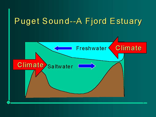
The Puget Sound is part of a large estuarine system that includes the Strait of Juan de Fuca and the Strait of Georgia. Typical of a fjord estuary, net motion of surface water in Puget Sound is seaward of the estuary, and net motion of deep water is landward.
Fig 3- PUGET SOUND - A FJORD ESTUARY
Exchange of deep nutrient rich oceanic water closely follows seasonal cycles in river runoff. Ebbesmeyer et al (1988) found that changes in river input follow an interdecadal cycle, and their analysis of Admiralty Inlet current profiles showed that the exchange of deep water into Puget Sound follows this interdecadal cycle (closely associated with the PDO) as well.
Fig 4- SALTWATER INPUT INTO PUGET SOUND
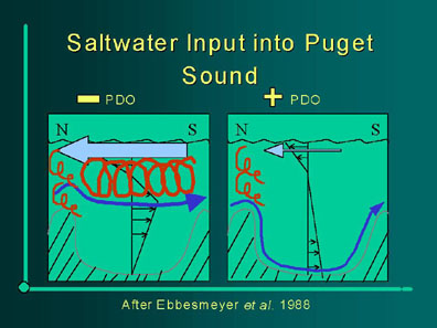
When the PDO is positive, precipitation in the Puget Sound Basin is below average and temperatures are warmer than average, thus reducing both winter (rain affected) and spring (snowmelt affected) streamflow into Puget Sound. Changes in streamflow will produce changes in density of the surface water which enhances or retards estuarine circulation. This difference in density causes the incoming oceanic water to either enter along the bottom (PDO+) or mid-depth (PDO-) depending on the vertical density gradient. The phase of the PDO not only influences the magnitude of streamflow but causes variations in the timing of both autumn and spring peaks in river discharge. Decadal scale changes in Puget Sound circulation affect conditions necessary for phytoplankton blooms that support the ecological pathway optimal for fish such as salmon.
Pinnix (1999) performed a statistical analysis of a number of climate variables recorded over time in the Puget Sound Basin. These included sea surface temperature, air temperature, precipitation and snowpack. Performing a statistical analysis on these collected variables, Pinnix came up with two major modes of Puget Sound Basin climate variability. The first mode operates at both the interdecadal and interannual time scales, contrasts warm/dry conditions with cold/wet conditions, and is closely associated with the PDO at the interdecadal scale as well as ENSO at the interannual scale.
Fig 5- PRINCIPLE COMPONENT ANALYSIS
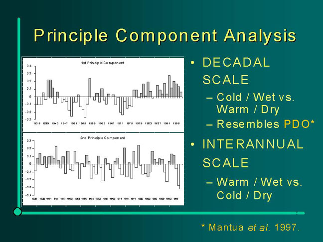
The second mode operates at the interannual time scale, contrasts warm/wet with cold/dry conditions, and has very little association with either PDO or ENSO.
Pinnix (1999) hypothesizes that climate-driven changes in inputs to Puget Sound, freshwater and saltwater, directly affect biological components of the Sound, in particular the production of phytoplankton. He proposes an optimal mixing window for plankton production which can be framed in terms of the PDO and ENSO.
Fig 6- FIGURE SHOWING OPTIMAL MIXING WINDOW
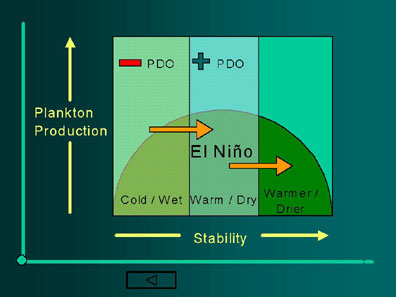
In this model, PDO and ENSO tend to operate in concert pushing the conditions to the right as they both move into their positive phases. This model indicates that the time between 1977 and 1990, conditions were optimal for Puget Sound plankton production (PDO+, near average streamflow conditions). Prior to 1977 (PDO-) conditions were suboptimal due to high streamflows leading to strong estuarine circulation and too much mixing in the Sound. The conditions since 1990 seem to be an enhancement of the positive PDO signal with a protracted El Nino condition in the early 1990s, thus pushing the conditions to the right of optimal.
Puget Sound Coho Salmon and Climate
A number of recent studies have suggested that marine survival is established during early marine residency (Francis and Hare 1994, Pearcy 1992). Evidence from the Oregon coast suggests that the majority of marine mortality occurs in the first three months of ocean residency. Gargett (1997) has proposed the existence of an "optimal stability window" for early marine survival, where ocean conditions allow phytoplankton populations to be maintained close to the surface in favorable light conditions and, at the same time, be resupplied with nutrients as a result of mixing from below. She further argued that the northern and southern extremes of Pacific salmon coastal habitat occupy opposite ends of this window. This hypothesis applies nicely to Puget Sound, with optimal conditions for phytoplankton blooms occurring when there is a balance between mixing, light and water column stratification.
After spending over a year in freshwater, naturally reared coho salmon begin their seaward migration in the spring. They then spend months in Puget Sound before moving out into the Straits of Juan de Fuca and then the open ocean.
The time series of Puget Sound coho salmon (hatchery) marine survival shows significant steps (abrupt changes) in mean levels at 1978 and 1990.
Fig 6- PUGET SOUND COHO MARINE SURVIVAL
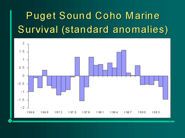
These shifts coincide with shifts in other NE Pacific (Alaska - California) salmon production (Mantua et al 1997, Hare et al 1999) but have a different pattern than other west coast salmon populations. The Puget Sound coho marine survival follows more of an Alaskan pattern (low production in the 1970s, higher production in the 1980s) up until 1990 when production fell off in Puget Sound (as well as much of the Pacific Northwest) but remained at record levels in Alaska. One assumes that the rise in marine survival in the 1980s was due to changes in the circulation of Puget Sound that favored the plankton-producing pathway that supports coho salmon.
As a result of this analysis, Pinnix (1999) proposes an optimal mixing window hypothesis that favors plankton production and coho marine survival in years with intermediate freshwater input to the Sound.
Relating this to the characterization of Puget Sound climate, the negative PDO period from 1947-1976 was predominantly a cool/wet regime thus increasing freshwater input and shifting the frame of the mixing window to the right of optimal conditions. The period from 1977-1989 was a time of near normal streamflow and thus optimal conditions for young coho in the Sound. The 1990s seemed to be an amplification of the positive PDO signal of the 1980s, with sea surface temperatures higher in both winter and summer than the 1980s. Trenberth and Hoar (1996, 1997) document a protracted El Nino which occurred in the early 1990s which could have served to boost coastal ocean temperatures throughout the NE Pacific. They also speculate that recent changes in the ENSO process may be related to increases in atmospheric greenhouse gases. In addition to elevated ocean temperatures, snowpack was much lower than normal while streamflow increased slightly during winter, and remained relatively unchanged, and low, during summer. This suggests that estuarine circulation was similar in the 1980s and 1990s, but stability increased with warmer surface temperatures which led to less mixing of nutrients up into the euphotic zone. In addition, it is possible that the 1990s warming of surface waters outside of Puget Sound decreased the oceanic exchange of water, further increasing stratification and conditions unfavorable for coho-preferred plankton production.
Beamish et al (1998) present a broader discussion of why trends in coho marine survival are quite different between the Strait of Georgia, Puget Sound and the Oregon coast. Additional references are suggested below in the "Suggested Readings" section of this chapter.
Physical and Biological Oceanography
Burns, Robert The Shape and Form of the Puget Sound. Seattle: Sea Grant, University of Washington Press, 1985.
Downing, John The Coast of the Puget Sound, Its Processes and Development. Seattle: Sea Grant, University of Washington Press, 1983.
Strickland, Richard The Fertile Fjord, Plankton in the Puget Sound. Seattle: Sea Grant, University of Washington Press, 1983.
Cannon, G.A., D.E. Bretschneider, and J.R. Holbrook (1984). Transport variability in a fjord, in The Estuary as a Filter, V.S. Kennedy (ed.), Academic Press, pp. 67-78.
Bretschneider, D.E., G.A.-Cannon, J.R.-Holbrook, and D.J.-Pashinski (1985).- Variability of subtidal current structure in a fjord estuary: Puget Sound, Washington, J.-Geophys.-Res., 90, 11949-11958. [circulation processes; intrusions and wind effects]
Cannon, G.A., J.R.-Holbrook, and D.J.-Pashinski (1990). Variations in the onset of bottom-water intrusions over the entrance sill of a fjord. Estuaries, 13, 31-42. [intrusions]
Matsuura, H., and G.A. Cannon (1997). Wind effects on sub-tidal currents in Puget Sound, J. Oceanogr., 53, 53-66. [winds]
Cannon, G.A.,-and D.E.-Bretschneider (1986). Interchanges between coastal and fjord circulation, in Contaminant Fluxes through the Coastal Zone, G. Kullenberg (ed.), Rapp. P.-v. Reun. Cons. int. Explor. Mer, 188, 38-48.[Strait of Juan de Fuca]
Lavelle, J.W., E.D. Cokelet, and G.A. Cannon (1991). A model study of density intrusions into and circulation within a deep silled estuary: Puget Sound, J. Geophys. Res., 96, 16,779-16,800.[models]
Chapters 5&6 from The Fertile Fjord: Plankton in the Puget Sound, Richard Strickland, Puget Sound Books series, Washington Sea Grant Publication,
Puget Sound Water Quality Action Team. 1998. 1998 Puget Sound Update: Sixth Report of the Puget Sound Ambient Monitoring Program. Puget Sound Water Quality Action Team. Olympia, Washington.
Newton, J.A. 1995. Observations of El Nino weather conditions reflected in the temperatures and salinities of monitoring stations in Puget Sound.In Puget Sound Research '95 Proceedings, 2: 979-991.
Harrison, PJ, Mackas, DL, Frost, BW, Macdonald, RW and Crecelius, EA.1994. An Assessment of Nutrients, Plankton and Some Pollutants in the Water Column of Juan de Fuca Strait, Strait of Georgia and Puget Sound and their Transboundary Transport.
Mackas, DL and PJ Harrison, 1997. Nitrogenous nutrient sources and sinks in the Juan de Fuca Strait/Strait of Georgia/Puget Sound estuarine system: Assessing the potential for eutrophication. Estuarine Coastal and Shelf Science, 44:1-21.
Newton, J.A., S.L. Albertson, K. Nakata, and C. Clishe. 1998. Washington State Marine Water Quality in 1996 and 1997. Washington State Department of Ecology, Environmental Investigations and Laboratory Services Program, Publication #98-338, Olympia, WA.
Salmon and Oceanography:
Beamish, R.J., D. Noakes, G. McFarlane, W. Pinnix, R. Sweeting, J. King and M. Folkes. 1998. Trends in coho marine survival in relation to the regime concept.Can. Stock Assess Sec. Res. Doc. 98/171
Ebbesmeyer, C.C., C.A. Coomes, J.M. Cox, G.A. Cannon, and D.E. Bretschneider. 1988. Decade-long regimes of a fjord basin's oceanography, hydrology, and climatology: Puget Sound, 1916-1987. in Proceedings of the First Annual Meeting on Puget Sound Research, March 18-19, 1988, Seattle, WA.
Enfield, D.B. 1989. El Nino, past and present. Reviews of Geophysics 27:159-187
Francis, R.C. and S.R. Hare. 1994. Decadal-scale regime shifts in the large marine ecosystems of the Northeast Pacific: A case for historical science. Fish. Oceanogr. 3: 279-291.
Francis, R.C., S.R. Hare, A.B. Hollowed and W.S. Wooster. 1998. Effects of interdecadal climate variability on the oceanic ecosystems of the NE Pacific. Fish. Oceanogr.7(1):1-21.
Gargett, A.E. 1997. The optimal stability 'window': A mechanism underlying decadal fluctuations in North Pacific salmon stocks? Fish. Oceanogr. 6(2):109-117.
Hare, S.R. 1996. Low frequency climate variability and salmon production. Ph.D. dissertation, School of Fisheries, University of Washington, Seattle, 306pp.
Hare, S.R. and R.C. Francis. 1995. Climate change and salmon production in the Northeast Pacific Ocean. In: Climate Change and Northern Fish Populations. R.J. Beamish (ed.) Can. spec. Publ. Fish. Aquat. Sci. 121:357-372
Hare, S.R., N.J. Mantua and R.C. Francis. 1999. Inverse production regimes: Alaska and west coast Pacific salmon. Fisheries 24(1):6-14.
Hollowed, A.B. and W.S. Wooster (1992) Variability of winter ocean conditions and strong year classes of Northeast Pacific groundfish. ICES Mar. Sci. Symp. 195:433-444.
Mantua, N.J., S.R. Hare, Y. Zhang, J.M. Wallace, and R.C. Francis. 1997. A Pacific interdecadal climate oscillation with impacts on salmon production. Bull. Am. Met. Soc. 78(6):1069-1079.
McGowan, J.A., D.R. Cayan and L.M. Dorman. 1998. Climate-ocean variability and ecosystem response in the Northeast Pacific. Science 281:210-217.
Pearcy, W.G. 1992. Ocean Ecology of North Pacific Salmonids. University of Washington Press, Seattle.
Philander, S.G.H. 1990. El Nino, La Nina, and the Southern Oscillation. Academic Press, San Diego.
Piatt, J.F. and P. Anderson. 1995. Response of common murres to the Exxon Valdez oil spill and long-term changes in the Gulf of Alaska marine ecosystem. In: Exxon Valdez Oil Spill Symposium Proceedings. Rice et al (eds). AFS Symp. 18:720-737.
Pinnix, W.D. 1999. Climate and coho: A Puget Sound perspective. MS Thesis, School of Fisheries, University of Washington.
Trenberth, K.E. and T.J. Hoar. 1996. The 1990-1995 El Nino-Southern Oscillation event: Longest on record. Geophys. Res. Lett.23(1):57-60.
Trenberth, K.E. and T.J. Hoar. 1997. El Nino and climate change. Geophys. Res. Lett. 24(23):3057-3060.