
Ocean 582A - Drainage Basin Dynamics
Big Beef Creek
Collaborative Virtual Reality
GIS & Mapping
Physical Template
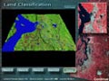
Remote Sensing
Scientific Visualization
Questions or
comments:
webmaster
Updated:
2002-12-12
|
 |
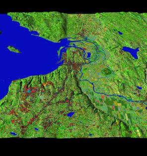 Spatial Information Technologies: Integrating GPS, GIS, and Remote Sensing for Earth Science and Natural Resources Planning Spatial Information Technologies: Integrating GPS, GIS, and Remote Sensing for Earth Science and Natural Resources Planning
In recent years the spatial information technologies of GPS (Global Positioning Systems), GIS (Geographic Information Systems) and Remote Sensing have made major advances in both the theoretical and applied basis for studies in the earth sciences. These technologies have become key components of interdisciplinary research and resources management practice.
This course is designed to introduce the use of GPS, GIS and Remote Sensing in the ecosystem sciences. In this course each student will participate in the collection of georeferenced field measurements and observations (GPS), importing those spatial data into a GIS, classifying the landcover over the spatial extent of those data from remotely sensed imagery, and analyzing their spatial variability. This applied course is intended to integrate these technologies in an applied setting, and to motivate students to incorporate these tools and techniques in their future work.
Course Home Page
|
|
Catalog Selections:
|
 |
| Band 2 |
 |
| Band 3 |
 |
| Band 4 |
 |
| Band 4,3,2 |
 |
| Class |
|