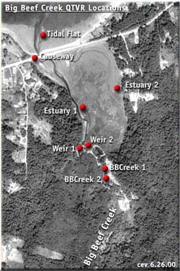
This map shows locations of panoramic imagery collected at Big Beef Creek on June 22, 2000. To view a panorama, click on a red dot or location title. The aerial photo- graphic imagery was taken from a US Geological Survey on June 21, 1990.
To navigate through in a panoramic QTVR, click on the mouse and drag in the appropriate direction to move right, left, up and down. To zoom in, hold down the shift key; to zoom out hold down the control key.
Viewing QTVR's requires a plug-in which you can download from our "plug-ins" page or directly from Apple's site.