Home Events News Links People Catalog Publications Admin

other active pages


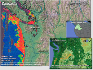
Collaborative Virtual Reality

GIS & Mapping

Scientific Visualization

Big Beef Creek

FISH 497 The Puget Sound Basin and Salmon

Ocean452 - Fish453 - FM490 - QSCI499

Ocean Productivity

Physical Template

Seismology & Geodynamics


Questions or
comments:

Miles Logsdon


Updated:
2002-11-21

This data is typically information about features, objects, and classes on the Earth land surface, oceans, and atmosphere.

Remote Sensing is detecting and measuring of electromagnetic energy emanating from distant objects made of various materials, so that we can identify and categorize these object by class or type, substance, and spatial distribution.

PRISM REMOTE SENSING